According to the project to adjust the general planning of Nha Trang City (former) until 2040 approved by the Prime Minister, along Cai River and other rivers, urban space, open park systems will be organized, combined with the development of waterway tourism. To realize this plan, Khanh Hoa province needs to soon have solutions to renovate and renovate rivers to ensure a green living environment; create a premise for developing tourism activities and services along the river.
Nha Trang is surrounded by a system of rivers and seas. Cai River is the main river with a length of 25km, bearing many historical imprints of its origins, while creating new values for the city. Other rivers such as Quan Truong River and Tac River are all branches of Cai River, which are important to the western communes. This connection proves that Cai River is a key geographical factor, creating the structure and natural characteristics of Nha Trang.
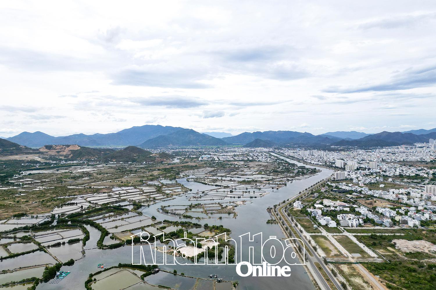 |
| Quan Truong River is proposed to be renovated and combined with developing waterway tourism. |
Nha Trang is also known for many unique cultural features with typical festivals, such as: Po Nagar Tower Festival; Fish Pray Festival; Salangane Nest Festival... Along with that are traditional craft villages that have existed for many generations, such as pottery, incense making, net weaving, fish sauce craft village... All festivals and craft villages are closely associated with the history of Nha Trang's formation. If the potential from natural conditions, unique cultural features, and traditional craft villages are well exploited, it will help the locality create new, valuable, attractive tourism products to attract tourists.
According to the proposed idea of the consulting unit on renovating and beautifying Quan Truong and Tac rivers combined with tourism, for Quan Truong river, it is divided into 5 sub-areas with the style of ocean riverside, including: Hoai Niem sub-area with a length of 2.7km, downstream of Cai River, it is proposed to build symbolic works, such as theater, riverside museum, outdoor riverside theater, art park, handicraft village exhibition; build culinary and commercial routes along the river. Lam Ha sub-area with a length of about 1.5km, inspired by ancient villages as a wild swamp area; with the highlight being walking routes, riverside landscape floors, ecological park. Thuong Pho sub-area with a length of about 1.5km, located close to the new administrative center, the highlight is the vibrant commercial and service routes along the river. The Mai Hoa sub-area is about 1.3km long, with the highlight being the linear park line using apricot blossoms as highlights along the river combined with an ecological park and an outdoor sports field. Finally, the Thuong Hoi sub-area is about 3km long, located where the river meets the sea; designed as an open stage for festivals, events and indigenous cultural experiences. This is a gathering place for memories, community life and festival tourism, contributing to preserving the urban soul, activating the night economy and creating a unique mark for the coastal city. The highlights in this subdivision are the riverside exhibition and display center, the riverside theater, live performance activities, boat racing, floating lanterns, etc. For Tac River, the idea is proposed with a natural ecological style, including the subdivisions: Thuy Nguyen, Tuyen Lam, Miet Vuon and Sinh Luc. The consulting unit also proposed a 15km Quan Truong River cruise route with 10 piers combined with an 18km long riverside ecological walkway; a 13km Song Tac River cruise route with 9 piers combined with a 20km long riverside ecological walkway. At the meeting on the design concept of the Project to renovate and develop tourism and service systems of the Tac River and Quan Truong River, Vice Chairman of the Provincial People's Committee Tran Hoa Nam requested the Provincial Development Project Management Board to coordinate with the consulting unit to collect opinions from departments, branches and sectors to complete the idea of unblocking the flow of rivers combined with developing economic tourism; synthesizing the idea report must show a clear orientation on the master plan, zoning plan, impact on projects preparing to be implemented in the area... The consulting unit reviewed the land plots along both sides of the river to have a specific orientation on establishing investment projects in each phase; completed in July 2025 for the Provincial People's Committee to report to the Provincial Party Committee Standing Committee for consideration and direction of implementation.
MANH HUNG
Translated by T.T


Thông tin bạn đọc
Đóng Lưu thông tin