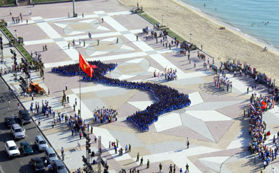
A giant Vietnam map was formed by 1,500 Youth unionists at 2-4 Square on Nha Trang beach on June 5 when a meeting was held to celebrate the 2011 Sea and Islands Week (June 1 – 8) in the city...
A giant Vietnam map was formed by 1,500 Youth unionists at 2-4 Square on Nha Trang beach on June 5 when a meeting was held to celebrate the 2011 Sea and Islands Week (June 1 – 8) in the city.
The 43.2 meter map includes the S-shaped land, two archipelagoes Truong Sa (Spratly) and Hoang Sa (Paracel) and Phu Quoc Island.
 |
| Giant Vietnam map created at Nha Trang’s main square |
In the melody of “Circle of unity” song, 1,500 Youth unionists stood hand in hand convey the meaning of Vietnam’s territory. The action not only expressed the Vietnamese youth’s patriotism but it was like their pledge of defending environment, maritime resources and sovereignty of the country.
The joining Youth unionists are students from colleges and universities in the city. Although in the examination, the students practiced hard for one week to finish the work in time.
Standing in the map, a student named Nguyen Ngoc Thuy said, “I really feel happy as being a part this Vietnamese map. I’m deeply aware of my country’s sovereign.”
Two other students Tran Trung Quoc and Pham Huy Hoang resolutely said, “We are very proud of creating two archipelagoes Spratly and Paracel in this map. We confirm that Spratly and Paracel belong to Vietnam. We will do our best to defend my country’s sovereign.”
The human map has propagandized patriotism and will of defending the country to the youth not only in the province but nationwide as well.
The map reached a scientific accuracy of 90%. It has been recognized as a Vietnam’s Guiness record by the Vietnam Record Book Center.
T.T