Funded by the French Government, Khanh Hoa Water Supply & Sewerage Company (KHAWASSCO) has put a geographic information system (GIS) into operation...
Funded by the French Government, Khanh Hoa Water Supply & Sewerage Company (KHAWASSCO) has put a geographic information system (GIS) into operation since 2013 as an effective tool for water resource management.
GIS is designed to capture, store, manipulate, analyze, manage, and present all types of geographical data. GIS has facilitated the KHAWASSCO staff to visualize, question, analyze and interpret data through maps and charts.
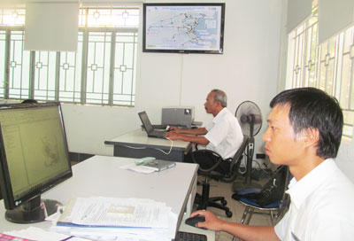 |
| GIS is applied in water supply operation and management. |
Nguyen Truong Vinh, a worker at Water Supply Network Operation & Management Office, says, “GIS makes our repair work more convenient as all customers’ information is stored in a geo-database and is easily accessed.”
According to Nguyen Duc Dai, Head of the Water Supply Network Operation & Management, GIS provides better ways of keeping record, acquiring natural resource data and processing customer data. It also helps to optimize maintenance schedules, save time and thus improve customer services. GIS helps to boost effectiveness of existing management tools such as water billing software and Excel, Word, Asset, etc.
To prepare for the new change, the company has implemented advanced technology through AutoCAD for 2 years. Up till now, the company has established a database of Nha Trang City water supply management with more than 73,000/92,000 water meters, over 11,000 main pipes, 840,000m long in total, 26 supervisory control and data acquisition (SCADA) positions, etc.
Xuan Phong and Vo Canh Water Supply Plants, under the KHAWASSCO, have updated their assets and facilities in Nha Trang City into GIS.
“GIS has helped the KHAWASSCO to modernize water supply management. However, there are some problems in terms of funding for copyright maintenance, software updating and staff’s English language capacity while using GIS,” confirms Director Tran Van Huy.
N.T