The Southern Central Regional Hydrometeorological Center in charge of hydrometeorological monitoring, investigation and warning in the provinces from Binh Dinh to Binh Thuan has made numerous achievements in applying science and technology in natural disaster control...
The Southern Central Regional Hydrometeorological Center in charge of hydrometeorological monitoring, investigation and warning in the provinces from Binh Dinh to Binh Thuan has made numerous achievements in applying science and technology in natural disaster control in the region over the past time.
Over 20 researches and projects on natural disaster control
The Southern Central Regional Hydrometeorological Center has had over 20 natural disaster risk researches and projects. The project directed by M.A Vo Anh Kiet on risk zoning and mapping for rainfall-induced landslides in Khanh Hoa Province has been examined and approved for the first phase of 2022 with research, survey and mapping for landslides caused by prolonged or heavy rainfall in Khanh Hoa Province and Nha Trang City in details; and solutions proposed to prevent and mitigate damages caused by landslides. In the first phase of the project, a map of landslide risk zoning in Nha Trang City, scale 1/10,000, has been completed for the city planning consideration.
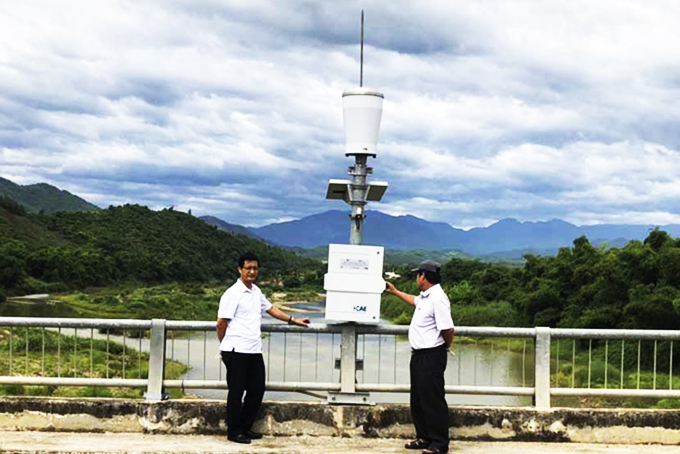
 A hydrometeorological station at Dong Tran Bridge, Dien Dong Commune, Dien Khanh District. A hydrometeorological station at Dong Tran Bridge, Dien Dong Commune, Dien Khanh District.
|
The project on developing technology for forecasting impacts and warning risks caused by storms, tropical depressions and floods in central provinces directed by M.A Tran Van Hung has been examined and approved. It assesses impacts and risks due to storms, tropical depressions and floods in the southern central provinces; deploys technologies to forecast impacts and warn risks caused by storms, tropical depressions and floods in the regional regions, according to the leader of the Southern Central Regional Hydrometeorological Center.
In addition, the environmental monitoring system has gradually improved over years with more than 200 automatic monitoring stations. The center is operating Weather Research and Forecasting (WRF) model with forecasts, 120 hours for 6km domain at hourly resolution. Its products consist of atmospheric forecast maps and forecast result files from stations. Apart from 2 weather surveillance radar stations for daily weather monitoring in Nha Trang and Quy Nhon, some forecasting models that integrate hydrological parameters on distribution, hydraulics and reservoirs using artificial intelligence to predict floods and inundation have proved effective.
Scientific research and transfer boosted
According to M.A Vo Anh Kiet, Director of Southern Central Regional Hydrometeorological Center, its staff are well-trained with 12 M.A, 52 hydrometeorological and scientific technological engineers, etc., meeting sufficient human resources for increasing hydrometeorological requirements. In the coming time, the center will continue conducting scientific and technological research and transfer; boosting the application of natural disaster forecasting and warning system in accordance with the center's conditions and capacity; developing and managing scientific and technological research and service database for sustainable socio-economic development.
Moreover, the center has continued boosting scientific technological application; research and application of the Industry 4.0 technologies; application of advanced science in remote sensing, GIS and so on in climate forecasting, disaster and extreme weather warning; survey and assessment of hydrometeorological resources and climate change monitoring; and development of hydrometeorological database. Besides, the research and application of science and technology focus on disaster risk zoning and warning; building a set of integrated hydrological models; developing marine hydrological forecasting tools; and promoting technologies to forecast rising water, sea waves and ocean currents in key coastal areas and economic zones.
V.L
Translated by N.T


